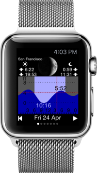
 Tide Table Chart
High tide and low tide forecasts:
St. Thomas Island : Charlotte Amalie
Lesser Antilles & Virgin Islands
St. Thomas Island : Charlotte Amalie
Lesser Antilles & Virgin Islands
Last High tide:
Next Low tide :
Next High tide:
Tide prediction details are in the chart below.
DISCLAIMER:
- The tide data are based on astronomical tide predictions and do not take into account the effects of strong winds, rain, floods and other meteorological events.
Do NOT use this app for navigation or any other purpose that may result in personal injury or property damage. Use it at your own risk.
feet(ft)
meter(m)
other location

Click left / right to see the tide chart of the next day or
play an animation of moon phase and tide changes to get a quick overview.
Whether you love to surf, dive, go fishing or simply enjoy walking on beautiful ocean beaches, Tide Table Chart will show you the tide predictions for St. Thomas Island : Charlotte Amalie and give the precise time of Sunrise, Sunset, Moonrise and Moonset.
Get Tide Table Chart as Android, iPhone or Smartwatch app:
New!Map Chart Mosaic
Offline maps for phone and smart watch: topo maps, satellite images, cycle and hiking trails...
Map views are automatically stored in an offline cache, so that you can view them later without an internet connection.
More info at www.MapChartMosaic.com
Map views are automatically stored in an offline cache, so that you can view them later without an internet connection.
More info at www.MapChartMosaic.com
Home About Us Products Fitbit FAQ Support Contact